|
TERMS OF USE:
This free image can only be used for non-commercial, personal
website use only. THIS IMAGE CANNOT BE
used in galleries, downloaded to your computer, posted on sites for
others to use, manipulated, downsized, or upsized. If you are confused about the
terms of use or have any questions then contact us before using the image.
Free Picture: Volga Delta and the Caspian Sea
|
Description
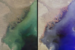
Russia's Volga River is the largest river system in Europe, draining over 1.3 million square kilometers of catchment area into the Caspian Sea. The brackish Caspian is Earth's largest landlocked water body, and its isolation from the world's oceans has enabled the preservation of several unique animal and plant species. The Volga provides most of the Caspian's fresh water and nutrients, and also discharges large amounts of sediment and industrial waste into the relatively shallow northern part of the sea. These images of the region were captured by the Multi-angle Imaging SpectroRadiometer on October 5, 2001, during Terra orbit 9567. Each image represents an area of approximately 275 kilometers x 376 kilometers. The left-hand image is from MISR's nadir (vertical-viewing) camera, and shows how light is reflected at red, green, and blue wavelengths. The right-hand image is a false color composite of red-band imagery from MISR's 60-degree backward, nadir, and 60-degree forward-viewing cameras, displayed as red, green, and blue, respectively. Here, color variations indicate how light is reflected at different angles of view. Water appears blue in the right-hand image, for example, because sun glitter makes smooth, wet surfaces look brighter at the forward camera's view angle. The rougher-textured vegetated wetlands near the coast exhibit preferential backscattering, and consequently appear reddish. A small cloud near the center of the delta separates into red, green, and blue components due to geometric parallax associated with its elevation above the surface. Other notable features within the images include several linear features located near the Volga Delta shoreline. These long, thin lines are artificially maintained shipping channels, dredged to depths of at least 2 meters. The crescent-shaped Kulaly Island, also known as Seal Island, is visible near the right-hand edge of the images.
Keywords
caspian sea, europe, geography, island, islands, jpl, kulaly island, nasa, russia, seal island, volga river, volga delta, free photography, free photo, free photos, free picture, free pictures, free image, free images
|
Similar Free geography Pictures
|
|
|
|


