|
TERMS OF USE:
This free image can only be used for non-commercial, personal
website use only. THIS IMAGE CANNOT BE
used in galleries, downloaded to your computer, posted on sites for
others to use, manipulated, downsized, or upsized. If you are confused about the
terms of use or have any questions then contact us before using the image.
Free Picture: Nyiragongo Volcano
|
Description
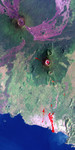
The Nyiragongo volcano in the Congo erupted on January 17, 2002, and subsequently sent streams of lava into the city of Goma on the north shore of Lake Kivu. More than 100 people were killed, more than 12,000 homes were destroyed, and hundreds of thousands were forced to flee the broader community of nearly half a million people. This Landsat satellite image shows the volcano (right of center), the city of Goma, and surrounding terrain. Image data from the Advanced Spaceborne Thermal Emission and Reflection Radiometer (ASTER) on NASA's Terra satellite were used to supply a partial map of the recent lava flows (red overlay), including a complete mapping of their intrusion into Goma as of January 28, 2002. Lava is also apparent within the volcanic crater and at a few other locations. Thick (but broken) cloud cover during the ASTER image acquisition prevented a complete mapping of the lava distribution, but future image acquisitions should complete the mapping. Goma has a light pink speckled appearance along the shore of Lake Kivu. The city airport parallels, and is just right (east) of, the larger lava flow. Nyiragongo peaks at about 3,470 meters (11,380 feet) elevation and reaches almost exactly 2,000 meters (6,560 feet) above Lake Kivu. The shorter but much broader Nyamuragira volcano appears in the upper left. Goma, Lake Kivu, Nyiragongo, Nyamuragira and other nearby volcanoes sit within the East African Rift Valley, a zone where tectonic processes are cracking, stretching, and lowering the Earth's crust. Volcanic activity is common here, and older but geologically recent lava flows (magenta in this depiction) are particularly apparent on the flanks of the Nyamuragira volcano. The Landsat image used here was acquired on December 11, 2001, about a month before the eruption, and shows an unusually cloud-free view of this tropical terrain.
Keywords
congo, earth science, east african rift valley, geography, goma, jpl, lake kivu, nasa, nyamuragira, nyamuragira volcano, nyiragongo, volcano, volcanoes, nyiragongo volcano, free photography, free photo, free photos, free picture, free pictures, free image, free images
|
Similar Free geography Pictures
|
|
|
|


