|
TERMS OF USE:
This free image can only be used for non-commercial, personal
website use only. THIS IMAGE CANNOT BE
used in galleries, downloaded to your computer, posted on sites for
others to use, manipulated, downsized, or upsized. If you are confused about the
terms of use or have any questions then contact us before using the image.
Free Picture: Costa Rica
|
Description
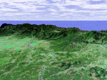
This perspective view shows the Caribbean coastal plain of Costa Rica, with the Cordillera Central rising in the background and the Pacific Ocean in the distance. The prominent river in the center of the image is the Rio Sucio, which merges with the Rio Sarapiqui at the bottom of the image and eventually joins with Rio San Juan on the Nicaragua border. Like much of Central America, Costa Rica is generally cloud covered so very little satellite imagery is available. The ability of the Shuttle Radar Topography Mission (SRTM) instrument to penetrate clouds and make three-dimensional measurements will allow generation of the first complete high-resolution topographic map of the entire region. These data were used to generate the image. This three-dimensional perspective view was generated using elevation data from SRTM and an enhanced false-color Landsat 7 satellite image. Colors are from Landsat bands 5, 4, and 2 as red, green and blue, respectively. Topographic expression is exaggerated two times.
Keywords
central america, cordillera central, geography, jpl, nasa, nicaragua, pacific ocean, rio san juan, rio sarapiqui, rio sucio, costa rica, free photography, free photo, free photos, free picture, free pictures, free image, free images
|
Similar Free geography Pictures
|
|
|
|


