|
TERMS OF USE:
This free image can only be used for non-commercial, personal
website use only. THIS IMAGE CANNOT BE
used in galleries, downloaded to your computer, posted on sites for
others to use, manipulated, downsized, or upsized. If you are confused about the
terms of use or have any questions then contact us before using the image.
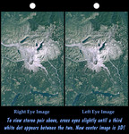
Free Picture: Mount St Helens, Washington
|
Description
On May 18, 1980, Mount St. Helens catastrophically erupted, causing the worst volcanic disaster in the recorded history of the United States. An earthquake shook loose the northern flank of the volcano, and about 2.8 cubic kilometers (0.67 cubic miles) of rock slid downslope in the world's largest recorded landslide. The avalanche released pressure on the volcano and unleashed a huge explosion, which was directed generally northward. The mountain ultimately lost 227 meters (1314 feet) of its height and devastated about 600 square kilometers (230 square miles) of forest. This stereoscopic view combines a Landsat satellite image with a Shuttle Radar Topography Mission elevation model to show the volcanic crater and most of the zone of devastation. Areas now relatively devoid of vegetation appear bright. Note the landslide debris clogging the northern drainages and forming natural dams (or enlarging previously existing ones). Also note the volcanic dome built up within the crater, and the extensive floating debris still present on Spirit Lake (northeast of the crater) 12 years after the eruption. This stereoscopic image was generated by draping a Landsat satellite image over a Shuttle Radar Topography Mission digital elevation model. Two differing perspectives were then calculated, one for each eye. They can be seen in 3-D by viewing the left image with the right eye and the right image with the left eye (cross-eyed viewing or by downloading and printing the image pair and viewing them with a stereoscope. When stereoscopically merged, the result is a vertically exaggerated view of Earth's surface in its full three dimensions.
Keywords
3d, earth science, geography, jpl, mount saint helens, mt saint helens, mt st helens, nasa, saint helens, spirit lake, st helens, volcano, volcanoes, washington, mount st helens, free photography, free photo, free photos, free picture, free pictures, free image, free images
|
Similar Free geography Pictures
|
|
|
|


