|
TERMS OF USE:
This free image can only be used for non-commercial, personal
website use only. THIS IMAGE CANNOT BE
used in galleries, downloaded to your computer, posted on sites for
others to use, manipulated, downsized, or upsized. If you are confused about the
terms of use or have any questions then contact us before using the image.
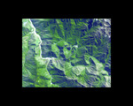
Free Picture: Machu Picchu, Peru
|
Description
The ruins of Machu Picchu, rediscovered in 1911 by Hiram Bingham, are one of the most beautiful and enigmatic ancient sites in the world. While the Inca people utilized the Andean mountain top (2800 m elevation), erecting massive stone structures from the early 1400's, legends and myths indicate that Machu Picchu (meaning "Old Peak" in the Quechua language) was revered as a sacred place from a far earlier time. The Inca turned the site into a small (12 square kilometers) but extraordinary city. Invisible from the Urubamba River valley below and completely self-contained, surrounded by agricultural terraces sufficient to feed the population, and watered by natural springs, Machu Picchu seems to have been utilized by the Inca as a secret ceremonial city. The Spaniards never found Machu Picchu, even though they suspected its existence. The mountain top sanctuary fell into disuse and was abandoned some forty years after the Spanish took Cuzco in 1533. Supply lines linking the many Inca social centers were disrupted and the great empire came to an end. This image was acquired on June 25, 2001 by the Advanced Spaceborne Thermal Emission and Reflection Radiometer (ASTER) on NASA's Terra satellite. With its 14 spectral bands from the visible to the thermal infrared wavelength region, and its high spatial resolution of 15 to 90 meters (about 50 to 300 feet), ASTER will image Earth for the next 6 years to map and monitor the changing surface of our planet.
Keywords
agricultural terraces, ancient ruins, andean mountain, geography, inca, jpl, machu picchu peru, nasa, peru, ruins, ruins of machu picchu, terraces, urubamba river valle, machu picchu, free photography, free photo, free photos, free picture, free pictures, free image, free images
|
Similar Free geography Pictures
|
|
|
|


