|
TERMS OF USE:
This free image can only be used for non-commercial, personal
website use only. THIS IMAGE CANNOT BE
used in galleries, downloaded to your computer, posted on sites for
others to use, manipulated, downsized, or upsized. If you are confused about the
terms of use or have any questions then contact us before using the image.
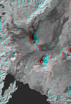
Free Picture: Nyiragongo Volcano, Congo
|
Description
The Nyiragongo volcano in the Congo erupted on January 17, 2002, and subsequently sent streams of lava into the city of Goma on the north shore of Lake Kivu. More than 100 people were killed, more than 12,000 homes were destroyed, and hundreds of thousands were forced to flee the broader community of nearly half a million people. This stereoscopic (anaglyph) visualization combines a Landsat satellite image and an elevation model from the Shuttle Radar Topography Mission (SRTM) to provide a view of the volcano, the city of Goma, and surrounding terrain. Nyiragongo is the steep volcano to the lower right of center, Lake Kivu is at the bottom, and the city of Goma is located along the northeast shore (bottom center). Nyiragongo peaks at about 3,470 meters (11,380 feet) elevation and reaches almost exactly 2,000 meters (6,560 feet) above Lake Kivu. The shorter but broader Nyamuragira volcano appears to the upper left of Nyiragongo. Goma, Lake Kivu, Nyiragongo, Nyamuragira and other nearby volcanoes sit within the East African Rift Valley, a zone where tectonic processes are cracking, stretching, and lowering the Earth's crust. The cliff at the top center of the image is the western edge of the rift. Volcanic activity is common in the rift, and older but geologically recent lava flows (dark in this depiction) are particularly apparent on the flanks of the Nyamuragira volcano. This anaglyph was produced by first shading an elevation model from data acquired by the Shuttle Radar Topography Mission and blending it with a single band of a Landsat scene. The stereoscopic effect was then created by generating two differing perspectives, one for each eye. When viewed through special glasses, the result is a vertically exaggerated view of the Earth's surface in its full three dimensions. Anaglyph glasses cover the left eye with a red filter and the right eye with a blue filter. The Landsat image used here was acquired on December 11, 2001, about a month before the eruption, and
Keywords
3d, anaglyph, congo, earth science, east african rift valley, geography, goma, jpl, lake kivu, nasa, nyamuragira, nyamuragira volcano, nyiragongo, volcano, volcanoes, nyiragongo volcano, free photography, free photo, free photos, free picture, free pictures, free image, free images
|
Similar Free geography Pictures
|
|
|
|


