|
TERMS OF USE:
This free image can only be used for non-commercial, personal
website use only. THIS IMAGE CANNOT BE
used in galleries, downloaded to your computer, posted on sites for
others to use, manipulated, downsized, or upsized. If you are confused about the
terms of use or have any questions then contact us before using the image.
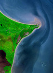
Free Picture: The Mosquito Coast
|
Description
Around 15 degrees North, a rounded point of land juts out into the Caribbean Sea from the Central American isthmus. This low-lying, wet area is called the Mosquito Coast, a corruption of the tribal name of some of the area’s native people, the Miskito. The area includes parts of Honduras (north) and Nicaragua (south). Between the two countries flows the Coco River, which empties into the Caribbean at Cape Gracias a Dios. This image of the Coco River and the Mosquito Coast is from the Advanced Spaceborne Thermal Emission and Reflection Radiometer (ASTER) on NASA ’s Terra satellite. In it, vegetation is shades of green, water is shades of blue and purple, and the beaches are very light tan. The variety of shades of blue and purple of the water may be due to water clarity and/or the calmness of the water, with clear, calm water in inland lakes and ponds appearing deep blue, and turbid or rough waters appearing more grayish and purple. The streaked appearance of the land in places to the north and south of the river is from relic shorelines. South of the river near the center-left edge of the scene, a meander (deep bend) in the river has been cut off from the main channel over time and is filling with vegetation. It appears as a bright green semicircle. The large image covers an area of 28.6 by 39.1 kilometers, and it was acquired on December 5, 2002. It is centered near 15 degrees North latitude, 83.3 degrees West longitude.
Keywords
cape gracias a dios, caribbean sea, central american isthmus, coco river, geography, honduras, isthmus, mosquito coast, nicaragua, river, rivers, the mosquito coast, free photography, free photo, free photos, free picture, free pictures, free image, free images
|
Similar Free geography Pictures
|
|
|
|


