|
TERMS OF USE:
This free image can only be used for non-commercial, personal
website use only. THIS IMAGE CANNOT BE
used in galleries, downloaded to your computer, posted on sites for
others to use, manipulated, downsized, or upsized. If you are confused about the
terms of use or have any questions then contact us before using the image.
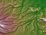
Free Picture: Pando Province, Northern Bolivia
|
Description
Pando Province, Bolivia, and adjacent parts of Brazil and Peru are seen in this visualization of Shuttle Radar Topography Mission (SRTM) elevation data covering part of the Amazon Basin. Most of this region is covered by tropical rainforest and is still largely unaltered by development, though new roads are providing increased access to the area, leading to changes in the landscape. SRTM data provide the first detailed three-dimensional look at the landforms of this region, and the Amazon Basin in its entirety, and will be particularly helpful in understanding the hydrologic patterns as environmental management becomes increasingly important. River drainage across this area flows generally east-northeast away from the nearby Andes Mountains. The most prominent river channels seen here are the Purus River in the northwest (upper left) and the Madre de Dios River, which crosses the south central (lower central) part of this view. The Beni and Mamore Rivers combine with the Madre de Dios in the eastern (right central) area to form the Madeira River, which flows northeast to eventually meet the Amazon River near Manaus. The Trans-Amazon Highway crosses the northern half of the scene, and subtle evidence of rainforest clear cutting, facilitated by this easy access, is apparent just north of the scene center, even at the low resolution of this display (740 m or 2428 feet). As seen here, clear cutting patterns in the rainforest typically show a pattern of parallel lines. SRTM mapped the shape of the Earths solid surface (not exclusively the ground surface), which includes to some degree land covers such as forests. Thus, SRTM data are capable of revealing deforestation patterns.
Keywords
amazon basin, amazon river, andes mountains, beni river, bolivia, brazil, geography, jpl, madeira river, madre de dios river, mamore river, nasa, northern bolivia, peru, purus river, transamazon highway, pando province, free photography, free photo, free photos, free picture, free pictures, free image, free images
|
Similar Free geography Pictures
|
|
|
|


