|
TERMS OF USE:
This free image can only be used for non-commercial, personal
website use only. THIS IMAGE CANNOT BE
used in galleries, downloaded to your computer, posted on sites for
others to use, manipulated, downsized, or upsized. If you are confused about the
terms of use or have any questions then contact us before using the image.
Free Picture: Where Europe Meets Africa
|
Description
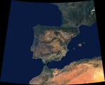
Data from a portion of the imagery acquired by the Multi-angle Imaging SpectroRadiometer's vertical-viewing (nadir) camera during 2000-2002 were combined to create this cloud-free natural-color mosaic of southwestern Europe and northwestern Morocco and Algeria. The image extends from 48°N, 16°W in the northwest to 32°N, 8°E in the southeast. It is displayed in Albers conic equal-area projection (a projection which is frequently used for equal-area maps of regions that are predominantly east-west in extent). From the northeast, the image traverses a portion of the Swiss Alps (partially snow-covered) and a small part of Italy's Po Valley. The northern portion of the image also includes the western coast of France and much of southern and southwestern France's undulating terrain, which continues until reaching the hills of the Pyrenees. The Pyrenees act as the natural frontier to the Iberian Peninsula -- a landmass comprised of Spain and Portugal. The Peninsular landscapes are extremely varied, with some almost desert-like, others green and fertile. About half of Spain is situated atop a high plain, known as the Central Plateau, and many mountain ranges, rivers, geological basement rock and vegetation types are found across this great plateau. The largest alluvial plain is Andalusia in the south, where the valley of the Guadalquivir River is shut in by mountain ranges on every side except the southwest, where the valley descends to the Atlantic. The islands of Mallorca, Menorca and Ibiza are Spanish territories in the western Mediterranean. At the Strait of Gibralter, Spain and Morocco very nearly kiss, and Morocco appears relatively verdant along its northern coastal corner. The rugged Atlas Mountain ranges traverse northern Algeria and Morocco.
Keywords
africa, algeria, andalusia, atlas mountain ranges, atlas mountains, central plateau, continent, earth science, europe, france, geography, guadalquivir river, iberian peninsula, ibiza, italy, jpl, mallorca, menorca, morocco, nasa, po valley, portugal, pyrenees, spain, strait of gibralter, swiss alps, where europe meets africa, free photography, free photo, free photos, free picture, free pictures, free image, free images
|
Similar Free geography Pictures
|
|
|
|


