|
TERMS OF USE:
This free image can only be used for non-commercial, personal
website use only. THIS IMAGE CANNOT BE
used in galleries, downloaded to your computer, posted on sites for
others to use, manipulated, downsized, or upsized. If you are confused about the
terms of use or have any questions then contact us before using the image.
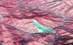
Free Picture: Landslide in Kashmir
|
Description
This 3D perspective view combines an image acquired by the Advanced Spaceborne Thermal Emission and Reflection Radiometer on NASA's Terra spacecraft on October 11, 2005 with digital topography from the Shuttle Radar Topography Mission. It depicts a large landslide in an area about 5 kilometers (3 miles) wide approximately 50 km southeast of the epicenter of the magnitude 7.6 Pakistan earthquake on October 8, 2005. The landslide (brownish gray color) slid down a mountain in the Pir Punjal (or Pir Panjal) range of Kashmir between Muzaffarabad and Uri, and has blocked two small rivers. Small lakes (dark blue color) have started to form behind the landslide. The center of the image is at about 34 degrees, 9 minutes North; 73 degrees, 43 minutes East. A number of smaller landslides are also visible as gray patches, mostly along the main river (Jhelum River) and other valleys. The red color is vegetation in this false-color image, and the view direction is from the southeast.
Keywords
3d, earth science, geography, jhelum river, jpl, kashmir, landslide, landslides, nasa, pir panjal, pir punjal, science, topography, landslide in kashmir, free photography, free photo, free photos, free picture, free pictures, free image, free images
|
Similar Free geography Pictures
|
|
|
|


