|
TERMS OF USE:
This free image can only be used for non-commercial, personal
website use only. THIS IMAGE CANNOT BE
used in galleries, downloaded to your computer, posted on sites for
others to use, manipulated, downsized, or upsized. If you are confused about the
terms of use or have any questions then contact us before using the image.
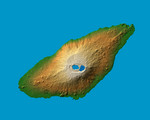
Free Picture: Ambae Island, Vanuatu
|
Description
The recently active volcano Mt. Manaro is the dominant feature in this shaded relief image of Ambae Island, part of the Vanuatu archipelago located 1400 miles northeast of Sydney, Australia. About 5000 inhabitants, half the island's population, were evacuated in early December from the path of a possible lahar, or mud flow, when the volcano started spewing clouds of steam and toxic gases 10,000 feet into the atmosphere. Last active in 1996, the 1496 meter (4908 ft.) high Hawaiian-style basaltic shield volcano features two lakes within its summit caldera, or crater. The ash and gas plume is actually emerging from a vent at the center of Lake Voui (at left), which was formed approximately 425 years ago after an explosive eruption. Two visualization methods were combined to produce the image: shading and color coding of topographic height. The shade image was derived by computing topographic slope in the northwest-southeast direction, so that northwest slopes appear bright and southeast slopes appear dark. Color coding is directly related to topographic height, with green at the lower elevations, rising through yellow and tan, to white at the highest elevations.
Keywords
active volcano, active volcanoes, ambae, earth science, geography, island, islands, jpl, manaro, mount manaro, mt manaro, nasa, south pacific, vanuatu, ambae island, free photography, free photo, free photos, free picture, free pictures, free image, free images
|
Similar Free geography Pictures
|
|
|
|


