|
TERMS OF USE:
This free image can only be used for non-commercial, personal
website use only. THIS IMAGE CANNOT BE
used in galleries, downloaded to your computer, posted on sites for
others to use, manipulated, downsized, or upsized. If you are confused about the
terms of use or have any questions then contact us before using the image.
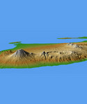
Free Picture: Mts. Agung and Batur, Bali
|
Description
This perspective view shows the major volcanic group of Bali, one 13,000 islands comprising the nation of Indonesia. The conical mountain to the left is Gunung Agung, at 3,148 meters (10,308 feet) the highest point on Bali and an object of great significance in Balinese religion and culture. Agung underwent a major eruption in 1963 after more than 100 years of dormancy, resulting in the loss of over 1,000 lives. In the center is the complex structure of Batur volcano, showing a caldera (volcanic crater) left over from a massive catastrophic eruption about 30,000 years ago. Judging from the total volume of the outer crater and the volcano, that once lay above it, approximately 140 cubic kilometers (33.4 cubic miles) of material must have been produced by this eruption, making it one of the largest known volcanic events on Earth. Batur is still active and has erupted at least 22 times since the 1800's.
Keywords
bali, batur volcano, caldera, earth science, eka dasa rudra, geography, gunung agung, indo australian tectonic plate, indonesia, island, islands, jpl, nasa, provinces of indonesia, stratovolcano, sunda plate, volcanic island, island of bali, free photography, free photo, free photos, free picture, free pictures, free image, free images
|
Similar Free geography Pictures
|
|
|
|


