|
TERMS OF USE:
This free image can only be used for non-commercial, personal
website use only. THIS IMAGE CANNOT BE
used in galleries, downloaded to your computer, posted on sites for
others to use, manipulated, downsized, or upsized. If you are confused about the
terms of use or have any questions then contact us before using the image.
Free Picture: Netherlands Dikes
|
Description
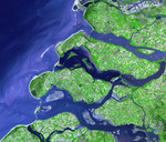
On the night of January 31, 1953, a combination of high spring tides and a strong windstorm caused the North Sea to surge onto coastal areas of the United Kingdom and the Netherlands, causing a major natural disaster. Thousands of lives were lost both on land and at sea. After the tragic event, the Netherlands undertook a major engineering project known as “Delta Works.” The project involved the fortification of seawalls, expansion of canals, and construction of dikes, dams, and locks. The southwestern coastline of the Netherlands, shown here, was especially vulnerable because it was composed of a series of islands crisscrossed with river outlets and estuaries. This image shows the results of the Delta Works project on the islands of the Netherlands southernmost coastal province, known as Zealand, which translates to “Sea Land.” Islands, once unconnected, are today linked by dikes and seawalls, and rivers and estuaries once open directly to the North Sea are enclosed as lakes. The patchwork of green, cream, and lavender colors on the islands shows the prevalence of agriculture in the province and fields in various stages of growth or harvest. The islands are cut through by the blue ribbons of canal, such as the Scheldt-Rhine Canal that flows into the image at lower right, cuts through Tholen Island and ends in the Krammer Strait. In the Eastern Scheldt Estuary, several light purple sandbars sit below the surface of the water. The high-resolution image shows ships in some of the canals and in the North Sea. This image was acquired on September 24, 2002, by the Advanced Spaceborne Thermal Emission and Reflection Radiometer (ASTER) on NASA’s Terra satellite. The full version of the scene covers an area of about 50.6 by 52.4 kilometers, and it is centered near 51.7 degrees North latitude, 4 degrees East longitude.
Keywords
canal, canals, delta works, eastern scheldt estuary, geography, island, islands, keeten mastgat strait, krammer strait, lake grevelingen, lake veere, lakes, nasa, netherlands, north sea, scheldt-rhine canal, tholen island, zandkreek strait, zealand, netherlands dikes, free photography, free photo, free photos, free picture, free pictures, free image, free images
|
Similar Free geography Pictures
|
|
|
|


