|
TERMS OF USE:
This free image can only be used for non-commercial, personal
website use only. THIS IMAGE CANNOT BE
used in galleries, downloaded to your computer, posted on sites for
others to use, manipulated, downsized, or upsized. If you are confused about the
terms of use or have any questions then contact us before using the image.
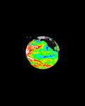
Free Picture: Fire and Deforestation near the Xingu River
|
Description
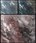
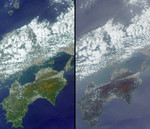
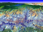
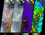
Numerous fires occurred near the headwaters of the Xingu River and the Xingu Indigenous Peoples' Reserve in Mato Grosso, Brazil, during late June and early July. These data products from the Multi-angle Imaging SpectroRadiometer (MISR) depict smoke abundance and the heights attained by smoke plumes on June 29, 2004. The four image panels extend from the Xingu headwaters region (upper right), to the great alluvial fan of the Taquari River in Mato Grosso do Sul (lower left) and just beyond the Brazil-Paraguay border. In addition to the four-image panel, an animation comparing the Xingu headwaters region on May 26, 2000 and May 21, 2004, illustrates land use changes that have occurred over the past four years. The opportunity for fires to occur in new areas of the Amazon forests tends to increase as new roads are established and more land is cleared. The left and center-left panels are natural color views from MISR's nadir and 70° backward-viewing cameras, respectively. A stereoscopic height field (center-right) and an aerosol optical depth retrieval (right) were generated using automated processing of data from multiple MISR cameras. Heights were retrieved for clouds, and also for smoke that exhibited sufficient spatial contrast between several view angles to be retrieved by MISR's feature matching algorithm. Several noticeably thick wisps of smoke (situated below and to the left of image center) echo the shapes of the northeast-southwest trending mountain ranges of the Planalto do Mato Grosso. Analysis of the wind-corrected stereo height field indicates that the smoke attained heights about 3.5 kilometers above the surface, and cumulus clouds attained heights about one kilometer higher. Terrain elevation data are displayed when the stereo matcher determines that a location is not covered by a feature above the surface, and areas where height could not be retrieved are shown in dark gray. In the lower left, a pall of smoke not clearly discernible at the nadir view is
Keywords
amazon, amazon forest, amazon forests, brazil, deforestation, earth science, environment, environmental, fire, fires, jpl, mato grosso, mato grosso do sul, nasa, planalto do mato grosso, smoke, taquari river, xingu headwaters region, xingu river, fire and deforestation near the xingu river, free photography, free photo, free photos, free picture, free pictures, free image, free images
|
Similar Free environmental Pictures
|
|
|
|