|
TERMS OF USE:
This free image can only be used for non-commercial, personal
website use only. THIS IMAGE CANNOT BE
used in galleries, downloaded to your computer, posted on sites for
others to use, manipulated, downsized, or upsized. If you are confused about the
terms of use or have any questions then contact us before using the image.
Free Picture: Smoke Soars to Stratospheric Heights
|
Description
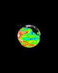
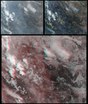
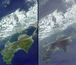
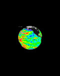
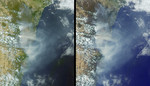
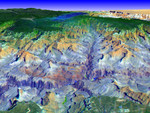
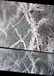
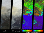
A new look at smoke from the Chisholm forest fire, which ignited on May 23, 2001 about 160 kilometers north of Edmonton in Alberta, Canada, provides confirming evidence that dense smoke can reach the upper troposphere and lower stratosphere. Scientists have postulated a link between fires in northern forests and the observed enhancements in stratospheric aerosols, but it is difficult to measure smoke aerosol heights directly. Here, height information for the Chisholm fire was retrieved using stereoscopic processing of data from multiple Multi-angle Imaging SpectroRadiometer (MISR) cameras. These images were acquired on May 29, when the severity of the fire had begun to stabilize after a cold front and strong low-level winds caused rapid spread of flame and an eruption of large-scale convection on May 28. This dramatic event was studied in detail by M. Fromm and R. Servranckx, "Transport of forest fire smoke above the tropopause by supercell convection", Geophys. Res. Lett., vol. 30, no. 10 (2003). The two left-hand images are natural color views from MISR's nadir and 60° forward viewing cameras in which a pall of yellowish smoke is apparent both above the surface and above clouds in the top portion of the images. This area is near the junction of Canada's Keewatin region and Northwest Territory, and about 1200 km northward of the originalfire location. Lake Athabasca is at the lower left. The second panel from the right is MISR's standard stereo height product (derived from the nadir and the two 26° cameras), while the right-hand panel is a specially-generated product using MISR's 46° and 60° forward-pointing cameras. Because the smoke appears thicker at the oblique view angles, better areal coverage is obtained and the retrievals are less sensitive to the underlying cloud deck. The southern portion of the smoke cloud is at an altitude of about 3.5 km; however, the smoke further to the north has risen above the tropopause (which is at about 11 km altitude) and intru
Keywords
alberta, canada, chisholm fire, chisholm forest fire, earth science, environment, environmental, fire, fires, forest fire, forest fires, jpl, keewatin region, lake athabasca, nasa, smoke, smoke soars to stratospheric heights, free photography, free photo, free photos, free picture, free pictures, free image, free images
|
Similar Free environmental Pictures
|
|
|
|