|
TERMS OF USE:
This free image can only be used for non-commercial, personal
website use only. THIS IMAGE CANNOT BE
used in galleries, downloaded to your computer, posted on sites for
others to use, manipulated, downsized, or upsized. If you are confused about the
terms of use or have any questions then contact us before using the image.
Free Picture: Floodwaters Renew Zambia's Kafue Wetland
|
Description
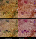
Not all floods are unwanted. Heavy rainfall in southern Africa between December 2003 and April 2004 provided central Zambia with floodwaters needed to support the diverse uses of water within the Kafue Flats area. The Kafue Flats are home to about one million people and provide a rich inland fishery, habitat for an array of unique wildlife, and the means for hydroelectricity production. The Flats falls between two dams: Upstream to the west (not visible here) is the Izhi-tezhi, and downstream (middle right of the images) is the Kafue Gorge dam. Since the construction of these dams, the flooded area has been reduced and the timing and intensity of the inundation has changed. During June 2004 an agreement was made with the hydroelectricity company to restore water releases from the dams according to a more natural flooding regime. These images from NASA's Multi-angle Imaging SpectroRadiometer (MISR) illustrate surface changes to the wetlands and other surfaces in central Zambia resulting from an unusually lengthy wet season. The Kafue Flats appear relatively dry on July 19, 2003 (upper images), with the Kafue River visible as a slender dark line that snakes from east to west on its way to join the Zambezi (visible in the lower right-hand corner). On July 21, 2004 (lower images), well into the dry season, much of the 6,500-square kilometer area of the Kafue Flats remains inundated. To the east of the Kafue Flats is Lusaka, the Zambian capital, visible as a pale area in the middle right of the picture, north of the river. In the upper portions of these images is the prominent roundish shape of the Lukanga Swamp, another important wetland. The images along the left are natural-color views from MISR's nadir camera, and the images along the right are angular composites in which red band data from MISR's 46° forward, nadir, and 46° backward viewing cameras is displayed as red, green and blue, respectively. In order to preserve brightness variations among the various cameras
Keywords
earth science, environment, environmental, flood, flooding, floods, geography, jpl, kafue flats, kafue gorge dam, kafue national park, kafue wetland, lukanga swamp, nasa, wetland, wetlands, zambia, zambias kafue wetland, floodwaters, free photography, free photo, free photos, free picture, free pictures, free image, free images
|
Similar Free geography Pictures
|
|
|
|


