|
TERMS OF USE:
This free image can only be used for non-commercial, personal
website use only. THIS IMAGE CANNOT BE
used in galleries, downloaded to your computer, posted on sites for
others to use, manipulated, downsized, or upsized. If you are confused about the
terms of use or have any questions then contact us before using the image.
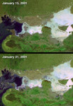
Free Picture: Dewatering Effects from the Gujarat Earthquake
|
Description
On January 26, 2001, when India's Republic Day is normally celebrated, a devastating earthquake hit the state of Gujarat. About 20,000 people died and millions were injured throughout the region. The earthquake had a magnitude of 7.7 on the Richter scale. After the earthquake, local residents reported a mixture of water and sediments fountaining from the Earth. These effects, referred to as dewatering, can result from intense groundshaking by strong earthquakes in regions with shallow water tables. Scientists initially observed dewatering in parts of the Rann of Kutch (a large salt pan in northern Gujarat), and in areas close to the earthquake epicenter. Recent research utilizes the unique capabilities of the Multi-angle Imaging SpectroRadiometer (MISR) instrument to observe earthquake-related dewatering over a broader area (related story). This research is published in the February 4, 2003 issue of EOS Transactions of the American Geophysical Union. These two false-color MISR images were acquired before and after the event, on January 15 and 31, respectively. The earthquake epicenter was located about 80 kilometers east of the city of Bhuj, situated in the lower part of the images. The later image depicts numerous areas where groundwater flowed up to the surface, including within the Rann of Kutch, as well as near the Indo-Pakistani border. These regions of earthquake-associated surface water are apparent up to 200 kilometers from the earthquake's epicenter. Water was observed in many remote areas, especially near the Indo-Pakistani border, which were not easily accessible to survey teams on the ground.
Keywords
aftermath, dewatering, dewatering effects, earth science, earthquake, earthquake aftermath, earthquakes, geography, gujarat earthquake, jpl, nasa, dewatering effects from the gujarat earthquake, free photography, free photo, free photos, free picture, free pictures, free image, free images
|
Similar Free geography Pictures
|
|
|
|


