|
TERMS OF USE:
This free image can only be used for non-commercial, personal
website use only. THIS IMAGE CANNOT BE
used in galleries, downloaded to your computer, posted on sites for
others to use, manipulated, downsized, or upsized. If you are confused about the
terms of use or have any questions then contact us before using the image.
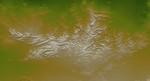
Free Picture: Davenport Ranges, Northern Territory, Australia
|
Description
The Davenport Ranges of central Australia have been inferred to be among the oldest persisting landforms on Earth, founded on the belief that the interior of Australia has been tectonically stable for at least 700 million years. New rock age dating techniques indicate that substantial erosion has probably occurred over that time period and that the landforms are not nearly that old, but landscape evolution certainly occurs much slower here (at least now) than is typical across Earth's surface. Regardless of their antiquity, the Davenport Ranges exhibit a striking landform pattern as shown in this display of elevation data from the Shuttle Radar Topography Mission (SRTM). Quartzites and other erosion resistant strata form ridges within anticlinal (arched up) and synclinal (arched down) ovals and zigzags. These structures, if not the landforms, likely date back at least hundreds of millions of years, to a time when tectonic forces were active. Maximum local relief is only about 60 meters (about 200 feet), which is enough to contrast greatly with the extremely low relief surrounding terrain.
Keywords
australia, earth science, geography, jpl, nasa, northern territory, davenport ranges, free photography, free photo, free photos, free picture, free pictures, free image, free images
|
Similar Free geography Pictures
|
|
|
|


