|
TERMS OF USE:
This free image can only be used for non-commercial, personal
website use only. THIS IMAGE CANNOT BE
used in galleries, downloaded to your computer, posted on sites for
others to use, manipulated, downsized, or upsized. If you are confused about the
terms of use or have any questions then contact us before using the image.
Free Picture: Earth Resources Technology Satellite (ERTS) 6/28/1971
|
Description
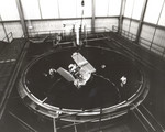
Photo of ERTS. The Earth Resources Technology Satellite (ERTS) mock-up in a space chamber test at General Electric's Space Division. The ERTS program represented a concentrated effort to observe and monitor the limited resources of the Earth, in order to best conserve and utilize the resources in support of a burgeoning world population. The first ERTS was launched in 1972 and was later named Land Remote-Sensing Satellite (Landsat), to better represent the civil satellite program's prime emphasis on remote sensing of land resources. Multiple sensors survey and relay back masses of data in various ways from the Landsat. NASA has built 7 Land Remote Sensing Satellites, which have helped agricultural experts pick up underutilized land areas and new prospects for land use through irrigation. It has also assisted in pinpointing the spread of crop disease and in charting new uses of the sea for oceanographers.
Keywords
astronomy, earth science, erts, general electrics space division, landsat, nasa, remote sensing satellites, satellites, earth resources technology satellite, free photography, free photo, free photos, free picture, free pictures, free image, free images
|
Similar Free nasa Pictures
|
|
|
|