|
TERMS OF USE:
This free image can only be used for non-commercial, personal
website use only. THIS IMAGE CANNOT BE
used in galleries, downloaded to your computer, posted on sites for
others to use, manipulated, downsized, or upsized. If you are confused about the
terms of use or have any questions then contact us before using the image.
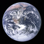
Free Picture: Full Earth 12/07/1972
|
Description
Image of a full view of the Earth as seen by the Apollo 17 crew traveling toward the Moon. This translunar coast photograph extends from the Mediterranean Sea area to the Antarctica South polar ice cap. This is the first time the Apollo trajectory made it possible to photograph the South polar ice cap. Note the heavy cloud cover in the Southern Hemisphere. Almost the entire coastline of Africa is clearly visible. The Arabian Peninsula can be seen at the Northeastern edge of Africa. The large island off the coast of Africa is the Malagasy Republic. The Asian mainland is on the horizon toward the Northeast.
Keywords
apollo 17, astronomy, earth, earth from space, earth science, from space, nasa, planet, planet eart, view from space, apollo 17 earth, free photography, free photo, free photos, free picture, free pictures, free image, free images
|
Similar Free astronomy Pictures
|
|
|
|