|
TERMS OF USE:
This free image can only be used for non-commercial, personal
website use only. THIS IMAGE CANNOT BE
used in galleries, downloaded to your computer, posted on sites for
others to use, manipulated, downsized, or upsized. If you are confused about the
terms of use or have any questions then contact us before using the image.
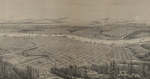
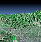
Free Picture: 3-D Perspective Pasadena, California
|
Description
Image of Pasadena, California. This perspective view shows the western part of the city of Pasadena, California, looking north towards the San Gabriel Mountains. Portions of the cities of Altadena and La Canada, Flintridge are also shown. The image was created from three datasets: the Shuttle Radar Topography Mission (SRTM) supplied the elevation data; Landsat data from November 11, 1986 provided the land surface color (not the sky) and U.S. Geological Survey digital aerial photography provides the image detail. The Rose Bowl, surrounded by a golf course, is the circular feature at the bottom center of the image. The Jet Propulsion Laboratory is the cluster of large buildings north of the Rose Bowl at the base of the mountains. A large landfill, Scholl Canyon, is the smooth area in the lower left corner of the scene. This image shows the power of combining data from different sources to create planning tools to study problems that affect large urban areas. In addition to the well-known earthquake hazards, Southern California is affected by a natural cycle of fire and mudflows. Wildfires strip the mountains of vegetation, increasing the hazards from flooding and mudflows for several years afterwards. Data such as shown on this image can be used to predict both how wildfires will spread over the terrain and also how mudflows will be channeled down the canyons. The Shuttle Radar Topography Mission (SRTM), launched on February 11, 2000, uses the same radar instrument that comprised the Spaceborne Imaging Radar-C/X-Band Synthetic Aperture Radar (SIR-C/X-SAR) that flew twice on the Space Shuttle Endeavour in 1994. The mission was designed to collect three dimensional measurements of the Earth's surface. To collect the 3-D data, engineers added a 60-meter-long (200-foot) mast, an additional C-band imaging antenna and improved tracking and navigation devices. The mission is a cooperative project between the National Aeronautics and Space Administration (NASA), the National Imagery and Mapping Agency (NIMA) and the German (DLR) and Italian (ASI) space agencies. It is managed by NASA's Jet Propulsion Laboratory, Pasadena, CA, for NASA's Earth Science Enterprise, Washington, DC. Size: 5.8 km (3.6 miles) x 10 km (6.2 miles) Location: 34.16 deg. North lat., 118.16 deg. West lon. Orientation: Looking North Original Data Resolution: SRTM, 30 meters; Landsat,30 meters; Aerial Photo, 3 meters (no vertical exaggeration) .
Keywords
altadena, california, flintridge, geological survey, jet propulsion laboratory, jpl, la canada, mountains, nasa, nima, pasadena california, rose bowl, san gabriel mountains, scholl canyon, shuttle radar topography, shuttle radar topography mission, srtm, topography, pasadena, free photography, free photo, free photos, free picture, free pictures, free image, free images
|
Similar Free Pictures of mountains
|
|
|
|