|
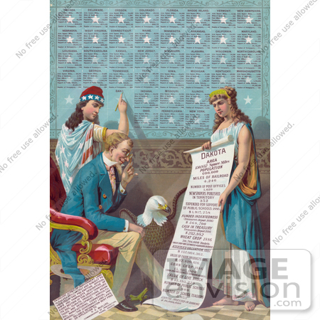
Royalty-free historical stock photo of the personification of Liberty, a woman wearing stars and strips, writing information on the Dakota Area on a board with information on other states. Here you see Uncle Sam Reading a Scroll of which the female personifciation of Dakota holds, and a Bald Eagle between them, c 1887. The scroll reads: Dakota Area - 150,932 Square Miles - Population 600,000 - Miles of Railroad 4,246 - Number of Post Offices 1,039 - Newspapers Published in Territory 352 - Expended For Support of Public Schools 1886 $1,917,258 - Funded Indebtedness (Treasurer’s Report 1886) $568,700 - Cash in Treasury Treasurer’s Report 1886 $232,982 - Wheat Crop 1886 30,704,000 Bushels (Wheat Crop 1887, Estimated 40,000,000 Bushels) - Assessed Valuation, 1887. $157,084,365. - Value of Farm Products 1885. $32,430,816. - Corn Crop 1886 15,805,000 (Corn Crop 1887, Estimated 30,000,000 Bushels) - Value of Live Stock $43,195,229 - Number of Public Schools 3,900 - Number of School Teachers 5,055 - Capital Invested in Banking $10,000,000. The note ate the bottom left reads: 24,000,000 acres of government land in Dakota still vacant and subject to homestead and pre-emption. Official maps and pamphlets descriptive of every section of the great territory, its soil, climate, productions, advantages, and development, agricultural, manufacturing, commercial, and mineral, the government land laws, &c. reliable information sent free on application to P. F. McClure, Commissioner of Immigration, Pierre, Dakota. On the board, there is information on Nevada, Delaware, Oregon, Colorado, Florida, Rhode Island, Vermont, New Hampshire, Nebraska, West Virginia, Connecticut, Maine, Minnesota, Arkansas, California, Maryland, Louisiana, South Carolina, Kansas, New Jersey, Mississippi, Alabama, Wisconsin, North Carolina, Virginia, Georgia, Tennessee, Texas, Iowa, Michigan, Kentucky, Massachusetts, Indiana, Missouri, Illinois, Ohio, Pennsylvania, and New York. [0003-0803-0417-5718] by 0003
|