|
TERMS OF USE:
This free image can only be used for non-commercial, personal
website use only. THIS IMAGE CANNOT BE
used in galleries, downloaded to your computer, posted on sites for
others to use, manipulated, downsized, or upsized. If you are confused about the
terms of use or have any questions then contact us before using the image.
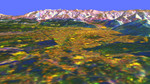
Free Picture: Missoula, Montana
|
Description
3d image of Missoula, Montana. The view is looking north-northeast. The blue circular area at the lower left corner is a bend of the Bitterroot River just before it joins the Clark Fork, which runs through the city. Crossing the Bitterroot River is the bridge of U.S. Highway 93. Highest mountains in this image are at elevations of 2,200 meters (7,200 feet). The city is about 975 meters (3,200 feet) above sea level. The bright yellow areas are urban and suburban zones, dark brown and blue-green areas are grasslands, bright green areas are farms, light brown and purple areas are scrub and forest, and bright white and blue areas are steep rocky slopes.
Keywords
3d, bitterroot river, geography, jpl, missoula, missoula montana, montana, nasa, free photography, free photo, free photos, free picture, free pictures, free image, free images
|
Similar Free geography Pictures
|
|
|
|


