|
TERMS OF USE:
This free image can only be used for non-commercial, personal
website use only. THIS IMAGE CANNOT BE
used in galleries, downloaded to your computer, posted on sites for
others to use, manipulated, downsized, or upsized. If you are confused about the
terms of use or have any questions then contact us before using the image.
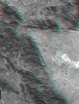
Free Picture: Los Angeles to San Joaquin Valley
|
Description
California's topography poses challenges for road builders. Northwest of Los Angeles, deformation of Earth's crust along the Pacific-North American crustal plate boundary has made transportation difficult. Direct connection between metropolitan Los Angeles (image lower left) and California's Central Valley (image top center) through the rugged terrain seen on the left side of this image was long avoided in favor of longer but easier paths. However, over the last century, three generations of roads have traversed this terrain. The first was "The Ridge Route", a two-lane road, built in 1915, which followed long winding ridge lines that included 697 curves. The second, built in 1933, was to become four-lane U.S. Highway 99. It generally followed widened canyon bottoms. The third is the current eight lane Interstate 5 freeway, built in the 1960s, which is generally notched into hillsides, but also includes a stretch of several miles where the two directions of travel are widely separated and driving is "on the left", a rarity in the United States. Such an unusual highway configuration was necessary in order to optimize the road grades for uphill and downhill traffic in this topographically challenging setting. This anaglyph was generated by first draping a Landsat satellite image over a preliminary topographic map from the Shuttle Radar Topography Mission, then generating two differing perspectives, one for each eye. When viewed through special glasses, the result is a vertically exaggerated view of the Earth's surface in its full three dimensions. Anaglyph glasses cover the left eye with a red filter and cover the right eye with a blue filter. Landsat has been providing visible and infrared views of the Earth since 1972. SRTM elevation data matches the 30 meter resolution of most Landsat images and will substantially help in analyses of the large and growing Landsat image archive.
Keywords
3d, anaglyph, anaglyphs, ca, calif, california, central valley, geography, jpl, los angeles, san joaquin valley, the ridge route, nasa, free photography, free photo, free photos, free picture, free pictures, free image, free images
|
Similar Free california Pictures
|
|
|
|