|
TERMS OF USE:
This free image can only be used for non-commercial, personal
website use only. THIS IMAGE CANNOT BE
used in galleries, downloaded to your computer, posted on sites for
others to use, manipulated, downsized, or upsized. If you are confused about the
terms of use or have any questions then contact us before using the image.
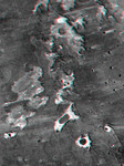
Free Picture: Meseta de Somuncura
|
Description
3D image of the Meseta de Somuncura, northern Patagonia. This view of the northwestern part of the plateau, near Los Menucos, Argentina, shows numerous depressions where the upper basalt layers are missing or collapsed. Collapse occurs above voids in the underlying rock. These voids might have been caused by lava tubes carrying away molten lava from under the cooled and solidified surface of a lava flow. Alternatively, voids might result when ground water dissolves carbonate (limestone) or evaporite(salt) deposits that the lava may be covering. Many of the depressions have salty lakes. Light wind streaks downwind(eastward) from the lakes show that salt crystals blow off the lake beds during dry times. Some eroded sand and silt debris from the basalt must also blow downwind, but the degree to which wind plays a role in the erosion of the depressions is not clear. This anaglyph was generated by first draping a Landsat Thematic Mapper image over a topographic map from the Shuttle Radar Topography Mission, then producing the two differing perspectives, one for each eye. When viewed through special glasses, the result is a vertically exaggerated view of the Earth's surface in its full three dimensions. Anaglyph glasses cover the left eye with a red filter and the right eye with a blue filter.
Keywords
3d, anaglyph, anaglyphs, argentina, basalt plateau, geography, jpl, los menucos, meseta de somuncura, patagonia, nasa, free photography, free photo, free photos, free picture, free pictures, free image, free images
|
Similar Free geography Pictures
|
|
|
|


