|
TERMS OF USE:
This free image can only be used for non-commercial, personal
website use only. THIS IMAGE CANNOT BE
used in galleries, downloaded to your computer, posted on sites for
others to use, manipulated, downsized, or upsized. If you are confused about the
terms of use or have any questions then contact us before using the image.
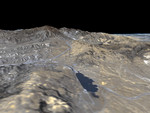
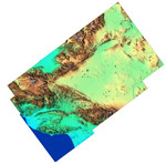
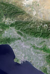
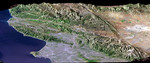
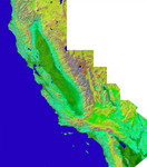
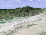
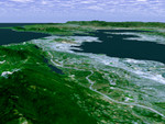
Free Picture: San Andreas Fault, Palmdale, California
|
Description
The prominent linear feature straight down the center of this perspective view is the San Andreas Fault. This segment of the fault lies near the city of Palmdale, California (the flat area in the right half of the image) about 60 kilometers (37 miles) north of Los Angeles. The fault is the active tectonic boundary between the North American plate on the right, and the Pacific plate on the left. Relative to each other, the Pacific plate is moving away from the viewer and the North American plate is moving toward the viewer along what geologists call a right lateral strike-slip fault. Two large mountain ranges are visible, the San Gabriel Mountains on the left and the Tehachapi Mountains in the upper right. The Lake Palmdale Reservoir, approximately 1.5 kilometers(0.9 miles) across, sits in the topographic depression created by past movement along the fault. Highway 14 is the prominent linear feature starting at the lower left edge of the image and continuing along the far side of the reservoir. The patterns of residential and agricultural development around Palmdale are seen in the Landsat imagery in the right half of the image. SRTM topographic data will be used by geologists studying fault dynamics and landforms resulting from active tectonics.
Keywords
ca, calif, california, fault, faults, geography, highway 14, jpl, lake palmdale reservoir, north american plate, pacific plate, palmdale, san andreas fault, san gabriel mountains, san gabriel mtns, tehachapi mountains, tehachapi mtns, nasa, free photography, free photo, free photos, free picture, free pictures, free image, free images
|
Similar Free san andreas fault Pictures
|
|
|
|