|
TERMS OF USE:
This free image can only be used for non-commercial, personal
website use only. THIS IMAGE CANNOT BE
used in galleries, downloaded to your computer, posted on sites for
others to use, manipulated, downsized, or upsized. If you are confused about the
terms of use or have any questions then contact us before using the image.
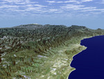
Free Picture: Santa Barbara, California
|
Description
Santa Barbara, California, is often called "America's Riviera." It enjoys a Mediterranean climate, a mountain backdrop, and a long and varied coastline. This perspective view of the Santa Barbara region was generated using data from the Shuttle Radar Topography Mission (SRTM) and an enhanced Landsat satellite image. The view is toward the northeast, from the Goleta Valley in the foreground to a snow-capped Mount Abel (elevation 2526 m or 8286 feet) along the skyline. The coast here generally faces south. Consequently, Fall and Winter sunrises occur over the ocean, which is unusual for the U.S. west coast. The Santa Barbara "back country" is very rugged and largely remains as undeveloped wilderness and an important watershed for local communities. Landsat has been providing visible and infrared views of the Earth since 1972. SRTM elevation data match the 30-meter resolution of most Landsat images and will substantially help in analyses of the large and growing Landsat image archive. For visualization purposes, topographic heights displayed in this image are exaggerated two times. Colors approximate natural colors.
Keywords
ca, calif, california, coastline, geography, goleta valley, jpl, mount abel, mt abel, santa barbara, santa barbara california, nasa, free photography, free photo, free photos, free picture, free pictures, free image, free images
|
Similar Free geography Pictures
|
|
|
|


