|
TERMS OF USE:
This free image can only be used for non-commercial, personal
website use only. THIS IMAGE CANNOT BE
used in galleries, downloaded to your computer, posted on sites for
others to use, manipulated, downsized, or upsized. If you are confused about the
terms of use or have any questions then contact us before using the image.
Free Picture: Mt. Fuji
|
Description
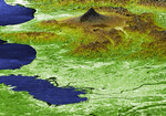
Japan's Mt. Fuji presents a beautiful backdrop for the city of Tokyo in this perspective view generated using data from the Shuttle Radar Topography Mission. Occupying most of the image foreground, Tokyo's metropolitan area, at about 13,388 square kilometers (5,169 square miles), is home to more than 32 million people, making it the most densely populated urban area in the world. Tokyo residents live within striking distance of Japan's tallest volcano, which is also the country's highest point at 3,776 meters(12,388 feet). Mt. Fuji is still considered active, although the last major eruption of this perfectly symmetrical stratovolcano came in 1707. Because of its height and spectacular scenery, Mt. Fuji is a favorite for touring, mountain climbing, hiking, and nature walking. In this image, elevations are represented by color; height increases from white to green to brown. For visualization purposes, topographic heights are exaggerated two times.
Keywords
fuji, geography, japan, jpl, mount fuji, mountain, mt fuji, tokyo, tokyo japan, nasa, free photography, free photo, free photos, free picture, free pictures, free image, free images
|
Similar Free geography Pictures
|
|
|
|


