|
TERMS OF USE:
This free image can only be used for non-commercial, personal
website use only. THIS IMAGE CANNOT BE
used in galleries, downloaded to your computer, posted on sites for
others to use, manipulated, downsized, or upsized. If you are confused about the
terms of use or have any questions then contact us before using the image.
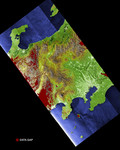
Free Picture: Tokyo, Honshu, Japan
|
Description
Much of Honshu, Japan's largest island, is seen in this image generated from the Shuttle Radar Topography Mission (SRTM) data. The nation of Japan is made up of four main islands and several smaller ones. Together they comprise a total land area of 374,744 square kilometers (144,689square miles), slightly less than the area of California. Forests and woodlands cover 67 percent of Japan's mostly rugged and mountainous terrain. In this image, elevations are represented by color; height increases from white to green to brown. Tokyo, the capital city, is the bright area in the bottom right part of the image. Of Japan's 127 million people, almost 80 percent live on Honshu, mostly in the flat coastal areas. The mountain peak visible to the left of Tokyo is Mt. Fuji, a stratovolcano famous for its perfectly shaped cone. This image was created during preliminary processing of a single data swath and contains numerous data gaps shown in red. These gaps will be filled in with data from overlapping swaths when the final elevation maps are produced.
Keywords
fuji, geography, honshu, japan, jpl, mount fuji, mountain, mt fuji, tokyo, tokyo japan, nasa, free photography, free photo, free photos, free picture, free pictures, free image, free images
|
Similar Free geography Pictures
|
|
|
|


