|
TERMS OF USE:
This free image can only be used for non-commercial, personal
website use only. THIS IMAGE CANNOT BE
used in galleries, downloaded to your computer, posted on sites for
others to use, manipulated, downsized, or upsized. If you are confused about the
terms of use or have any questions then contact us before using the image.
Free Picture: Fiji Islands
|
Description
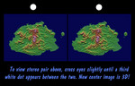
The Sovereign Democratic Republic of the Fiji Islands, commonly known as Fiji, is an independent nation consisting of some 332 islands surrounding the Koro Sea in the South Pacific Ocean. This topographic image shows Viti Levu, the largest island in the group. With an area of 10,429 square kilometers (about 4000 square miles), it comprises more than half the area of the Fiji Islands. Suva, the capital city, lies on the southeast shore. The Nakauvadra, the rugged mountain range running from north to south, has several peaks rising above 900 meters (about 3000 feet). Mount Tomanivi, in the upper center, is the highest peak at 1324 meters (4341 feet). The distinct circular feature on the north shore is the Tavua Caldera, the remnant of a large shield volcano that was active about 4 million years ago. Gold has been mined on the margin of the caldera since the 1930s. The Nadrau plateau is the low relief highland in the center of the mountain range. The coastal plains in the west, northwest and southeast account for only 15 percent of Viti Levu's area but are the main centers of agriculture and settlement.
Keywords
fiji, fiji islands, geography, island, islands, jpl, koro sea, mount tomanivi, nakauvadra, nakauvadra mountains, sovereign democratic republic, suva, tavua caldera, viti levu, nasa, free photography, free photo, free photos, free picture, free pictures, free image, free images
|
Similar Free geography Pictures
|
|
|
|


