|
TERMS OF USE:
This free image can only be used for non-commercial, personal
website use only. THIS IMAGE CANNOT BE
used in galleries, downloaded to your computer, posted on sites for
others to use, manipulated, downsized, or upsized. If you are confused about the
terms of use or have any questions then contact us before using the image.
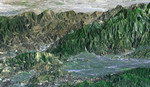
Free Picture: San Fernando Valley
|
Description
The San Fernando Valley (lower right of center) is part of Los Angeles and includes well over one million people. Two major disasters have occurred here in the last few decades: the 1971 Sylmar earthquake and the 1994 Northridge earthquake. Both quakes caused major damage to homes, freeways, and other structures and included major injuries and fatalities. The Northridge earthquake was the one of the costliest natural disasters in United States history. Understanding earthquake risks requires understanding a location's geophysical setting, and topographic data are of substantial benefit in that regard. Landforms are often characteristic of specific tectonic processes, such as ground movement along faults. Elevation models, such as those produced by the Shuttle Radar Topography Mission (SRTM), are particularly useful in visualizing regional scale landforms that are too large to be seen directly on-site. They can also be used to model the propagation of damaging seismic waves, which helps in urban planning. In recent years, elevation models have also been a critical input to radar interferometric studies, which reveal detailed patterns of ground deformation from earthquakes that had never before been seen.
Keywords
ca, calif, california, geography, jpl, los angeles, san fernando valley, san fernando valley california, valley, nasa, free photography, free photo, free photos, free picture, free pictures, free image, free images
|
Similar Free geography Pictures
|
|
|
|


