|
TERMS OF USE:
This free image can only be used for non-commercial, personal
website use only. THIS IMAGE CANNOT BE
used in galleries, downloaded to your computer, posted on sites for
others to use, manipulated, downsized, or upsized. If you are confused about the
terms of use or have any questions then contact us before using the image.
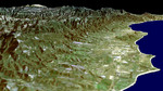
Free Picture: Santa Barbara Coastline
|
Description
This NASA image of the Santa Barbara, California, region provides a beautiful snapshot of the area's rugged mountains and long and varied coastline. Generated using data acquired from the Shuttle Radar Topography Mission (SRTM) and an enhanced Landsat image this is a perspective view toward the northeast, from the Goleta Valley in the foreground to a snow-capped Mount Abel (elevation 2,526 m or 8,286 feet) along the skyline at the left. On a clear day, a pilot might see a similar view shortly before touching down on the east-west runway of the Santa Barbara Airport, seen just to the left of the coastline near the center of image. This area is one of the few places along the U.S. West Coast where because of a south-facing beach, fall and winter sunrises occur over the ocean.
Keywords
ca, calif, california, coastline, geography, goleta valley, jpl, mount abel, mt abel, santa barbara, santa barbara airport, santa barbara ca, santa barbara calif, santa barbara california, santa barbara coastline, nasa, free photography, free photo, free photos, free picture, free pictures, free image, free images
|
Similar Free geography Pictures
|
|
|
|


