|
TERMS OF USE:
This free image can only be used for non-commercial, personal
website use only. THIS IMAGE CANNOT BE
used in galleries, downloaded to your computer, posted on sites for
others to use, manipulated, downsized, or upsized. If you are confused about the
terms of use or have any questions then contact us before using the image.
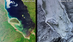
Free Picture: Summer and Winter, James Bay
|
Description
One year ago, in late February 2000, MISR began acquiring Earth imagery. Its "first light" images showed a frozen James Bay in the Ontario-Quebec region of Canada. These more recent nadir-camera views of the same area illuminate stark contrasts between summer and winter. The left-hand image was acquired on August 9, 2000 (Terra orbit 3427), and the right-hand image is from January 16, 2001 (Terra orbit 5757). James Bay lies at the southern end of Hudson Bay. It is named for the English explorer Thomas James, who first explored the area in 1631 while searching for the Northwest Passage. Visible in these images are some of the many rivers that flow into the bay; starting at the southern tip and moving clockwise on the western side are the Harricana, Moose, Albany, and Attawapiskat. The latter enters the bay just to the west of the large, crescent-shaped Akimiski Island.
Keywords
akimiski island, albany river, attawapiskat river, bay, canada, frozen james bay, geography, harricana river, hudson bay, island, islands, james bay, jpl, moose river, ontario, quebec, rivers, summer, winter, nasa, free photography, free photo, free photos, free picture, free pictures, free image, free images
|
Similar Free geography Pictures
|
|
|
|


