|
TERMS OF USE:
This free image can only be used for non-commercial, personal
website use only. THIS IMAGE CANNOT BE
used in galleries, downloaded to your computer, posted on sites for
others to use, manipulated, downsized, or upsized. If you are confused about the
terms of use or have any questions then contact us before using the image.
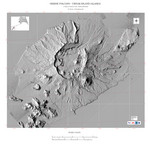
Free Picture: Umnak Island, Aleutian Islands, Alaska
|
Description
This image is a shaded relief mosaic of Umnak Island in Alaska's Aleutian Islands. It was created with Airsar data that was geocoded and combined into this mosaic as part of a NASA-funded Alaska Digital Elevation Model Project at the Alaska Synthetic Aperture Radar Facility (ASF) at the University of Alaska Geophysical Institute in Fairbanks, Alaska. Airsar collected the Alaska data as part of its PacRim 2000 Mission, which took the instrument to French Polynesia, American and Western Samoa, Fiji, New Zealand, Australia, New Guinea, Indonesia, Malaysia, Cambodia, Philippines, Taiwan, South Korea, Japan, Northern Marianas, Guam, Palau, Hawaii and Alaska. Airsar, part of NASA's Airborne Science Program, is managed for NASA's Earth Science Enterprise by JPL. JPL is a division of the California Institute of Technology in Pasadena.
Keywords
ak, alaska, aleutian islands, geography, island, islands, jpl, umnak, umnak island, nasa, free photography, free photo, free photos, free picture, free pictures, free image, free images
|
Similar Free geography Pictures
|
|
|
|


