|
TERMS OF USE:
This free image can only be used for non-commercial, personal
website use only. THIS IMAGE CANNOT BE
used in galleries, downloaded to your computer, posted on sites for
others to use, manipulated, downsized, or upsized. If you are confused about the
terms of use or have any questions then contact us before using the image.
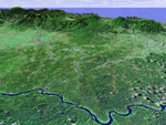
Free Picture: Costa Rica Coastal Plain
|
Description
This perspective view shows the northern coastal plain of Costa Rica with the Cordillera Central, composed of a number of active and dormant volcanoes, rising in the background. This view looks toward the south over the Rio San Juan, which marks the boundary between Costa Rica and Nicaragua. The smaller river joining Rio San Juan in the center of the image is Rio Sarapiqui, which is navigable upstream as far inland as Puerto Viejo (Old Port) de Sarapiqui at the mountain's base. This river was an important transportation route for those few hardy settlers who first moved into this region, although as recently as 1953 a mere three thatched-roof houses were all that comprised the village of Puerto Viejo. This coastal plain is a sedimentary basin formed about 50 million years ago composed of river alluvium and lahar (mud and ash flow) deposits from the volcanoes of the Cordillera Central. It comprises the province of Heredia (the smallest of Costa Rica's seven) and demonstrates a wide range of climatic conditions, from warm and humid lowlands to cool and damp highlands, and including the mild but seasonally wet and dry Central Valley.
Keywords
central valley, coastal plain, cordillera central, costa rica, costa rica coastal plain, geography, jpl, puerto viejo, puerto viejo de sarapiqui, rio san juan, rio sarapiqui, river, rivers, nasa, free photography, free photo, free photos, free picture, free pictures, free image, free images
|
Similar Free geography Pictures
|
|
|
|


