|
TERMS OF USE:
This free image can only be used for non-commercial, personal
website use only. THIS IMAGE CANNOT BE
used in galleries, downloaded to your computer, posted on sites for
others to use, manipulated, downsized, or upsized. If you are confused about the
terms of use or have any questions then contact us before using the image.
Free Picture: Wetlands of the Gulf Coast
|
Description
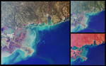
NASA image of the wetlands of the Gulf Coast. This set of images from the Multi-angle Imaging SpectroRadiometer highlights coastal areas of four states along the Gulf of Mexico: Louisiana, Mississippi, Alabama and part of the Florida panhandle. The images were acquired on October 15, 2001 (Terra orbit 9718)and represent an area of 345 kilometers x 315 kilometers. The two smaller images on the right are (top) a natural color view comprised of red, green, and blue band data from MISR's nadir (vertical-viewing) camera, and (bottom) a false-color view comprised of near-infrared, red, and blue band data from the same camera. The predominantly red color of the false-color image is due to the presence of vegetation, which is bright at near-infrared wavelengths. Cities appear as grey patches, with New Orleans visible at the southern edge of Lake Pontchartrain, along the left-hand side of the images. The Lake Pontchartrain Bridge runs approximately north-south across the middle of the lake. The distinctive shape of the Mississippi River Delta can be seen to the southeast of New Orleans. Other coastal cities are visible east of the Mississippi, including Biloxi, Mobile and Pensacola. The large image is similar to the true-color nadir view, except that red band data from the 60-degree backward-looking camera has been substituted into the red channel; the blue and green data from the nadir camera have been preserved. In this visualization, green hues appear somewhat subdued, and a number of areas with a reddish color are present, particularly near the mouths of the Mississippi, Pascagoula, Mobile-Tensaw, and Escambia Rivers. Here, the red color is highlighting differences in surface texture. This combination of angular and spectral information differentiates areas with aquatic vegetation associated with poorly drained bottom lands, marshes, and/or estuaries from the surrounding surface vegetation. These wetland regions are not as well differentiated in the conventional nadir views. Variations in ocean color are apparent in all three views, and represent the outflow of suspended sediment from the seabed shelf to the open waters of the Gulf of Mexico. Major features include the Mississippi Delta, where large amounts of land-derived sediments have been deposited in shallow coastal waters. These deltaic environments form a complex, interconnected web of estuarine channels and extensive coastal wetlands that provide important habitat for fisheries. The city of New Orleans is prone to flooding, with about 45% of the metropolitan core situated at or below sea level. The city is protected by levees, but the wetlands which also function as a buffer from storm surges have been disappearing.
Keywords
alabama, biloxi, environment, environmental, florida, florida panhandle, geography, gulf, gulf coast, gulf of mexico, jpl, lake pontchartrain, lake pontchartrain bridge, louisiana, mississippi, mississippi delta, mississippi river delta, mobile, new orleans, pensacola, wetland, wetlands, wetlands of the gulf coast, nasa, free photography, free photo, free photos, free picture, free pictures, free image, free images
|
Similar Free geography Pictures
|
|
|
|


