|
TERMS OF USE:
This free image can only be used for non-commercial, personal
website use only. THIS IMAGE CANNOT BE
used in galleries, downloaded to your computer, posted on sites for
others to use, manipulated, downsized, or upsized. If you are confused about the
terms of use or have any questions then contact us before using the image.
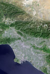
Free Picture: Los Angeles and Vicinity from Space
|
Description
Los Angeles and vicinity seen from space, as viewed by the Landsat 7 satellite from an altitude of 437 miles on May 4, 2001. North is at the top. Topographic shading has been enhanced using an elevation data set acquired by the Space Shuttle Endeavour in February 2000. Downtown Los Angeles is just south of the image center, with L.A. and Long Beach harbors to the south, Santa Monica Bay to the west, San Fernando Valley to the northwest, San Gabriel Valley to the east, and Orange County to the southeast. The San Andreas fault forms the straight diagonal mountain front bordering the Mojave Desert at the top of the image. At full resolution, features on the ground as small as 15 meters (49 feet) across can be distinguished, including street patterns and large buildings, as well as boats and their wakes on the ocean. More than ten million people live within this scene.
Keywords
ca, calif, california, geography, jpl, la, long beach, los angeles, los angeles and vicinity, los angeles ca, los angeles calif, los angeles california, los angeles from space, mojave desert, nasa, orange county, san andreas fault, san fernando valley, san gabriel valley, santa monica bay, view from space, from space, free photography, free photo, free photos, free picture, free pictures, free image, free images
|
Similar Free geography Pictures
|
|
|
|


