|
TERMS OF USE:
This free image can only be used for non-commercial, personal
website use only. THIS IMAGE CANNOT BE
used in galleries, downloaded to your computer, posted on sites for
others to use, manipulated, downsized, or upsized. If you are confused about the
terms of use or have any questions then contact us before using the image.
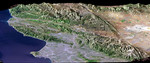
Free Picture: Los Angeles, California
|
Description
Los Angeles, Calif., is one of the world's largest metropolitan areas with a population of about 15 million people. The urban areas mostly cover the coastal plains and lie within the inland valleys. The intervening and adjacent mountains are generally too rugged for much urban development. This in large part because the mountains are "young", meaning they are still building (and eroding) in this seismically active (earthquake prone) region. Earthquake faults commonly lie between the mountains and the lowlands. The San Andreas fault, the largest fault in California, likewise divides the very rugged San Gabriel Mountains from the low-relief Mojave Desert, thus forming a straight topographic boundary between the top center and lower right corner of the image. We present two versions of this perspective image from NASA's Shuttle Radar Topography Mission (SRTM): one with and one without a graphic overlay that maps faults that have been active in Late Quaternary times (white lines). The fault database was provided by the U.S. Geological Survey. The Landsat image used here was acquired on May 4, 2001, about seven weeks before the summer solstice, so natural terrain shading is not particularly strong. It is also not especially apparent given a view direction (northwest) nearly parallel to the sun illumination (shadows generally fall on the backsides of mountains). Consequently, topographic shading derived from the SRTM elevation model was added to the Landsat image, with a false sun illumination from the left (southwest). This synthetic shading enhances the appearance of the topography.
Keywords
calif, california, geography, jpl, la, los angeles ca, los angeles calif, los angeles california, mojave desert, nasa, san andreas fault, san gabriel mountains, los angeles, free photography, free photo, free photos, free picture, free pictures, free image, free images
|
Similar Free geography Pictures
|
|
|
|


