|
TERMS OF USE:
This free image can only be used for non-commercial, personal
website use only. THIS IMAGE CANNOT BE
used in galleries, downloaded to your computer, posted on sites for
others to use, manipulated, downsized, or upsized. If you are confused about the
terms of use or have any questions then contact us before using the image.
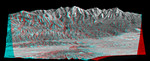
Free Picture: Malibu to Mount Baldy
|
Description
Mount San Antonio (more commonly known as Mount Baldy) crowns the San Gabriel Mountains northeast of Los Angeles in this computer-generated east-northeast anaglyph perspective viewed from above the Malibu coastline. On the right, the Pacific Ocean and Santa Monica are in the foreground. Further away are downtown Los Angeles and then the San Gabriel Valley, which lies adjacent to the mountain front. The San Fernando Valley appears in the left foreground, separated from the ocean by the Santa Monica Mountains. At 3,068 meters (10,064 feet) Mount Baldy rises above the tree line, exposing bright white rocks that are not snow capped in this early autumn scene. This anaglyph perspective (stereoscopic 3-D) view was generated using topographic data from the Shuttle Radar Topography Mission (SRTM) and a Landsat 7 satellite image. Topographic expression is exaggerated one and one-half times. Two perspectives (from slightly differing geographic positions) were created, one for each eye. When viewed through special glasses, the result is a near horizontal view of the Earth's surface in its full three dimensions. Anaglyph glasses cover the left eye with a red filter and cover the right eye with a blue filter.
Keywords
3d, anaglyph, ca, calif, california, geography, jpl, la, los angeles ca, los angeles calif, los angeles california, metro los angeles, mount baldy, mount san antonio, nasa, san fernando valley, san gabriel mountains, san gabriel valley, santa monica, santa monica mountains, malibu, free photography, free photo, free photos, free picture, free pictures, free image, free images
|
Similar Free geography Pictures
|
|
|
|


