|
TERMS OF USE:
This free image can only be used for non-commercial, personal
website use only. THIS IMAGE CANNOT BE
used in galleries, downloaded to your computer, posted on sites for
others to use, manipulated, downsized, or upsized. If you are confused about the
terms of use or have any questions then contact us before using the image.
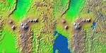
Free Picture: Virunga and Nyiragongo Volcanoes
|
Description
Volcanic, tectonic, erosional and sedimentary landforms are all evident in this comparison of two elevation models of a region along the East African Rift at Lake Kivu. The area shown covers parts of Congo, Rwanda and Uganda. These two images show exactly the same area. The image on the left was created using the best global topographic data set previously available, the U.S. Geological Survey's GTOPO30. In contrast, the much more detailed image on the right was generated with data from the Shuttle Radar Topography Mission, which collected enough measurements to map 80 percent of Earth's landmass at this level of precision. Elevation is color coded, progressing from green at the lower elevations through yellow to brown at the higher elevations. A false sun in the northwest (upper left) creates topographic shading. Lake Kivu is shown as black in the Shuttle Radar Topography Mission version (southwest corner). It lies within the East African Rift, an elongated tectonic pull-apart depression in Earth's crust. The rift extends to the northeast as a smooth lava- and sediment-filled trough. Two volcanic complexes are seen in the rift. The one closer to the lake is the Nyiragongo volcano, which erupted in January 2002, sending lava toward the lake shore and through the city of Goma. East of the rift, even more volcanoes are seen. These are the Virunga volcano chain, which is the home of the endangered mountain gorillas. Note that the terrain surrounding the volcanoes is much smoother than the eroding mountains that cover most of this view, such that topography alone is a good indicator of the extent of the lava flows. But this clear only at the higher spatial resolution of the shuttle mission's data set.
Keywords
congo, earth science, east african rift valley, geography, jpl, lake kivu, nasa, nyiragongo volcano, rwanda, tectonic, uganda, virunga volcano chain, volcanic, volcano, volcanoes, virunga volcano, free photography, free photo, free photos, free picture, free pictures, free image, free images
|
Similar Free geography Pictures
|
|
|
|


