|
TERMS OF USE:
This free image can only be used for non-commercial, personal
website use only. THIS IMAGE CANNOT BE
used in galleries, downloaded to your computer, posted on sites for
others to use, manipulated, downsized, or upsized. If you are confused about the
terms of use or have any questions then contact us before using the image.
Free Picture: Manila Bay, Philippines
|
Description
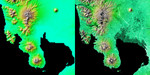
These two images show exactly the same area, Manila Bay and nearby volcanoes on Luzon Island in the Philippines. The image on the left was created using the best global topographic data set previously available, the U.S. Geological Survey's GTOPO30. In contrast, the much more detailed image on the right was generated with data from the Shuttle Radar Topography Mission, which collected enough measurements to map 80 percent of Earth's landmass at this level of precision. The city of Manila is on the eastern shore of Manila Bay at the right edge of the image. The large central plain to the north of the bay, irrigated by the Panpanga and Agno rivers, is the most important agricultural region in the Philippines. The Bataan Peninsula and volcanic Mt. Bataan at lower center along with the small island of Corregidor near the bottom edge became famous when the Allied forces made their last stand there during World War II. Dominating the upper left of the scene is 1,600 meter (5,249 foot) high Mt. Pinatubo, whose violent eruption on June 15, 1991, wrought widespread destruction on Luzon as well as injecting dust and gas into the atmosphere, which lowered global average temperatures for over a year. The image on the right combines two types of Shuttle Radar Topography Mission data. The image brightness corresponds to the strength of the radar signal reflected from the ground, while colors show the elevation measurements. Colors range from blue at the lowest elevations to brown and white at the highest elevations.
Keywords
agno river, bataan peninsula, bay, bays, corregidor, corregidor island, earth science, geography, island corregidor, jpl, luzon, luzon island, manila bay philippines, mount bataan, mount pinatubo, mt bataan, mt pinatubo, nasa, panpanga river, philippines, volcanoes, manila bay, free photography, free photo, free photos, free picture, free pictures, free image, free images
|
Similar Free geography Pictures
|
|
|
|


