|
TERMS OF USE:
This free image can only be used for non-commercial, personal
website use only. THIS IMAGE CANNOT BE
used in galleries, downloaded to your computer, posted on sites for
others to use, manipulated, downsized, or upsized. If you are confused about the
terms of use or have any questions then contact us before using the image.
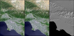
Free Picture: Los Angeles and Vicinity
|
Description
Digital elevation models (DEMs), such as those produced by the Shuttle Radar Topography Mission (SRTM), allow user-controlled visualization of the Earth's landforms that is not possible using satellite imagery alone. This three-view comparison shows Los Angeles, Calif., and vicinity, with a Landsat image (only) on the left, a shaded relief rendering of the SRTM DEM on the right, and a merge of the two data sets in the middle. Note that topographic expression in the Landsat image alone is very subtle due to the fairly high sun angle (63 degrees above the horizon) during the satellite overflight in late morning of a mid-Spring day (May 4, 2001). In contrast, computer generated topographic shading of the DEM provides a pure and bold image of topographic expression with a user specified illumination direction. The middle image shows how combining the Landsat and DEM shaded relief can result in a topographically enhanced satellite image in which the information content of both data sets is merged into a single view.
Keywords
ca, calif, california, geography, jpl, la, los angeles, los angeles ca, los angeles calif, los angeles california, nasa, los angeles and vicinity, free photography, free photo, free photos, free picture, free pictures, free image, free images
|
Similar Free geography Pictures
|
|
|
|


