|
TERMS OF USE:
This free image can only be used for non-commercial, personal
website use only. THIS IMAGE CANNOT BE
used in galleries, downloaded to your computer, posted on sites for
others to use, manipulated, downsized, or upsized. If you are confused about the
terms of use or have any questions then contact us before using the image.
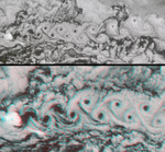
Free Picture: A Vortex Street in the Arctic
|
Description
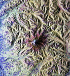
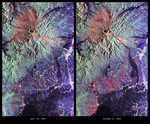
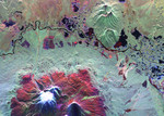
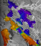
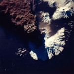
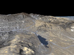
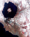
Marine stratocumulus clouds frequently form parallel rows, or "cloud streets", along the direction of wind flow. When the flow is interrupted by an obstacle such as an island, a series of organized eddies can appear within the cloud layer downwind of the obstacle. These turbulence patterns are known as von Karman vortex streets. In these images from NASA's Multi-angle Imaging SpectroRadiometer, an impressive vortex pattern continues for over three hundred kilometers southward of Jan Mayen island. Jan Mayen is an isolated territory of Norway, located about 650 kilometers northeast of Iceland in the north Atlantic Ocean. Jan Mayen's Beerenberg volcano rises about 2.2 kilometers above the ocean surface, providing a significant impediment to wind flow. These MISR images were captured on June 6, 2001, during Terra orbit 7808. The entire vortex street can be seen in the top panel, which is a natural-color view from the instrument's nadir (downward-looking) camera. The area covered measures 365 kilometers x 158 kilometers, and a cloud-clearing effect is apparent at the vortex centers until finally closing on the sixteenth "hole." The bottom panel is a stereo anaglyph of a portion of the vortex street, compiled using data from MISR's 26-degree forward and 70-degree backward viewing cameras. This view covers an area of about 183 kilometers x 96 kilometers. Despite the vertical exaggeration afforded by using widely separated angles, the relatively modest height variation in the cloud layer implies a vertically stable atmosphere. To facilitate stereo viewing, the images have been oriented with north at the left. Red/blue glasses should be used with the red filter placed over your left eye. Information on ordering glasses can be found here. Fluid dynamicist Theodore von Karman was the first to derive the conditions under which these turbulence patterns occur. Von Karman was a professor of aeronautics at the California Institute of Technology and one of the principal founders of
Keywords
arctic, cloud streets, clouds, earth science, jan mayens beerenberg volcano, jpl, karman vortex streets, marine stratocumulus clouds, nasa, stratocumulus clouds, vortex street, a vortex street in the arctic, free photography, free photo, free photos, free picture, free pictures, free image, free images
|
Similar Free earth science Pictures
|
|
|
|