|
TERMS OF USE:
This free image can only be used for non-commercial, personal
website use only. THIS IMAGE CANNOT BE
used in galleries, downloaded to your computer, posted on sites for
others to use, manipulated, downsized, or upsized. If you are confused about the
terms of use or have any questions then contact us before using the image.
Free Picture: San Francisco Bay Area
|
Description
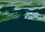
The cities of San Francisco and the East Bay are highlighted in this computer-generated perspective viewed from west of the Golden Gate. San Francisco occupies the peninsula jutting into the picture from the right. Golden Gate Park is the long rectangle near its left end and the Presidiois the green area at its tip, from which Golden Gate Bridge crosses to Marin. Treasure Island is the bright spot above San Francisco and Alcatraz Island is the small smudge below and to the left. Across the bay from San Francisco lie Berkeley (left) and Oakland (right). Mount Diablo, a landmark visible for many miles, rises in the distance at the upper right. This three-dimensional perspective view was generated using topographic data from the Shuttle Radar Topography Mission (SRTM) and an enhanced false-color Landsat 5 satellite image. Colors are from Landsat bands 3, 2, and 1 as red, green and blue, respectively. Topographic expression is exaggerated two times.
Keywords
3d, alcatraz, alcatraz island, bay area, berkeley, ca, calif, california, east bay, geography, golden gate, golden gate bridge, golden gate park, island, islands, jpl, marin, mount diablo, nasa, oakland, peninsula, presidiois, san fran, san francisco, sf, sf bay area, treasure island, san francisco bay area, free photography, free photo, free photos, free picture, free pictures, free image, free images
|
Similar Free geography Pictures
|
|
|
|


