|
TERMS OF USE:
This free image can only be used for non-commercial, personal
website use only. THIS IMAGE CANNOT BE
used in galleries, downloaded to your computer, posted on sites for
others to use, manipulated, downsized, or upsized. If you are confused about the
terms of use or have any questions then contact us before using the image.
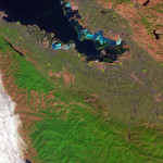
Free Picture: Salt Ponds in San Francisco Bay
|
Description
In coming years, the shores of San Francisco Bay south of the San Mateo Bridge will begin to look a bit more like their former, pre-developed selves. The South Bay Salt Pond Restoration Project will be converting several clusters of salt evaporation ponds, pictured in vivid color in this Advanced Spaceborne Thermal Emission and Reflection Radiometer (ASTER) image from October 6, 2003, back into the tidal marshes, mudflats and other wetland ecosystems that pre-date human development of the area. In the scene, ponds that are deep blue are inundated with water, while lighter and bright blue suggests ponds that are in various stages of evaporation, leaving behind the desired salt. Vegetation is bright green, bare soil is pinkish orange, and developed surfaces like cities and roads are light purple. Three areas will be converted in the project: the Eden Landing area, which occupies the right-hand side of the Bay south of the San Mateo Bridge (upper left) and north of the Alameda County Flood Control Canal (s-shaped arc); the Ravenswood Point Area on the left-hand side of the Bay north and south of the Dumbarton Bridge (just left of image center); and the Alviso area, which will encompass most of the very dark blue ponds in the southern end of the Bay. Wetland restoration has numerous benefits. Healthy wetlands are a natural water-purifying system, and they support more than 50 percent of the federally listed threatened or endangered species. They act as spawning grounds and nurseries for marine animals, and they control both erosion and flooding. Finally, they are important parts of recreation and tourism economies across the country.
Keywords
alameda county flood control canal, alviso area, bay, bays, california, dumbarton bridge, eden landing, environment, environmental, geography, pond, ponds, ravenswood point area, salt pond, salt ponds, salt ponds in san francisco bay, san fran, san francisco, san francisco bay, san mateo bridge, sf, sf bay, south bay salt pond restoration project, wetland restoration, nasa, free photography, free photo, free photos, free picture, free pictures, free image, free images
|
Similar Free geography Pictures
|
|
|
|


