|
TERMS OF USE:
This free image can only be used for non-commercial, personal
website use only. THIS IMAGE CANNOT BE
used in galleries, downloaded to your computer, posted on sites for
others to use, manipulated, downsized, or upsized. If you are confused about the
terms of use or have any questions then contact us before using the image.
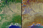
Free Picture: Rice Cultivation in Northwest Italy
|
Description
The lowlands of Lombardy and Piedmont in northwest Italy are some of the most highly developed irrigation areas in the world. Irrigated lands cover at least 160,000 acres in this part of Italy, where rice is the most important crop. These views of the region were acquired on May 8, 2005, by NASA's Multi-angle Imaging SpectroRadiometer (MISR). The multiangular nature of MISR allows wet surfaces and lands inundated with water to be differentiated from other surface types, and is also used here to identify cities. The left-hand image is a natural color view acquired by MISR's downward-looking (nadir) camera, and the right-hand image is a multi-angular composite. The composite was created using data from three of the MISR cameras, with red band data from MISR's 60º backward-viewing, nadir and 60º forward-viewing cameras, displayed as red, green and blue, respectively. Here, color changes indicate surface texture, which is influenced by terrain, vegetation structure, soil type and surface wetness. Wet surfaces or areas with standing water appear in blue or purple-blue hues, because sun glitter (an ensemble of specular reflection points) causes smooth, wet surfaces to look brighter to a camera that is pointing toward the Sun. The purple-blue areas indicate the extensive irrigation network that exists throughout the plains and meadows of Lombardy and Piedmont. Cities with tall buildings appear to be "rough" surfaces because of their vertical structures and appear in red-orange hues. Using this display technique, the cities of Milan and Vercelli can be readily identified. The area of orange pixels situated roughly at the center of the purple inundation area indicates the location of Vercelli, and Milan can be located by the large orange area that appears to the northeast of Vercelli. To a lesser extent, the cities of Novara, Pavia, Galliate, Mortara and Vigevano are also identifiable by their orange hues. MISR can detect these textural differences because of the way surface
Keywords
agriculture, crops, cultivation, galliate, golfo di genovam, irrigated lands, irrigation, italy, italy agriculture, jpl, lago maggiore, lombardy, lowland of lombardy, lowland of piedmont, milan, mortara, nasa, northwest italy, novara, pavia, piedmont, rice, rice crops, rice cultivation, vercelli, vigevano, rice cultivation in northwest italy, free photography, free photo, free photos, free picture, free pictures, free image, free images
|
Similar Free geography Pictures
|
|
|
|


