|
TERMS OF USE:
This free image can only be used for non-commercial, personal
website use only. THIS IMAGE CANNOT BE
used in galleries, downloaded to your computer, posted on sites for
others to use, manipulated, downsized, or upsized. If you are confused about the
terms of use or have any questions then contact us before using the image.
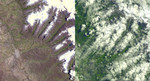
Free Picture: Potential Disaster in the Icy Andes
|
Description
An Earth-monitoring instrument aboard NASA's Terra satellite is keeping a close eye on a potential glacial disaster in the making in Peru's spectacular, snow-capped Cordillera Blanca (White Mountains), the highest range of the Peruvian Andes. Data from NASA's Advanced Spaceborne Thermal Emission and Reflection Radiometer (Aster) is assisting Peruvian government officials and geologists in monitoring a glacier that feeds Lake Palcacocha, located high above the city of Huaraz, 270 kilometers (168 miles) north of Lima. An ominous crack has developed in the glacier. Should the large glacier chunk break off and fall into the lake, the ensuing flood could hurtle down the Cojup Valley into the Rio Santa Valley below, reaching Huaraz, population 60,000, in less than 15 minutes. "Glacial natural hazards like the one in Huaraz are an increasing threat to people in many parts of the world," said Dr. Michael Abrams, associate Aster team leader at NASA's Jet Propulsion Laboratory, Pasadena, Calif. "Remote sensing instruments like Aster can serve a vital role in mountain hazard management and disaster mapping by providing rapid access to data, even in regions not easily accessible by humans. Aster's unique vantage point from space gives scientists another tool with which to see early signs of potential glacial flood-burst events and to monitor changes in glacial behavior over time. In Huaraz, Peruvian authorities and scientists will incorporate Aster data along with data from ground-based monitoring techniques to better assess current conditions and take steps necessary to reduce risks to human lives and property." Glacial flood-bursts, known by Peruvians as "aluviones," occur periodically when water is released abruptly from a previously ice-dammed lake alongside, within, or above a glacier. The release can be caused by various triggering events. These flood-bursts typically arrive with little or no warning, carrying liquid mud, large rock boulders and blocks of ice. The Rio San
Keywords
aluviones, andes, cojup valley, cordillera blanca, earth science, geography, glacial flood-bursts, jpl, lake palcacocha, nasa, peruvian andes, rio santa valley, white mountains, peru, free photography, free photo, free photos, free picture, free pictures, free image, free images
|
Similar Free geography Pictures
|
|
|
|


