|
TERMS OF USE:
This free image can only be used for non-commercial, personal
website use only. THIS IMAGE CANNOT BE
used in galleries, downloaded to your computer, posted on sites for
others to use, manipulated, downsized, or upsized. If you are confused about the
terms of use or have any questions then contact us before using the image.
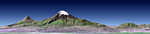
Free Picture: Mount Ararat, Turkey
|
Description
This perspective view shows Mount Ararat in easternmost Turkey, which has been the site of several searches for the remains of Noah's Ark. The main peak, known as Great Ararat, is the tallest peak in Turkey, rising to 5165 meters (16,945 feet). This southerly, near horizontal view additionally shows the distinctly conically shaped peak known as "Little Ararat" on the left. Both peaks are volcanoes that are geologically young, but activity during historic times is uncertain. This image was generated from a Landsat satellite image draped over an elevation model produced by the Shuttle Radar Topography Mission (SRTM). The view uses a 1.25-times vertical exaggeration to enhance topographic expression. Natural colors of the scene are enhanced by image processing, inclusion of some infrared reflectance (as green) to highlight the vegetation pattern, and inclusion of shading of the elevation model to further highlight the topographic features. Volcanoes pose hazards for people, the most obvious being the threat of eruption. But other hazards are associated with volcanoes too. In 1840 an earthquake shook the Mount Ararat region, causing an unstable part of mountain's north slope to tumble into and destroy a village. Visualizations of satellite imagery when combined with elevation models can be used to reveal such hazards leading to disaster prevention through improved land use planning. But the hazards of volcanoes are balanced in part by the benefits they provide. Over geologic time volcanic materials break down to form fertile soils. Cultivation of these soils has fostered and sustained civilizations, as has occurred in the Mount Ararat region. Likewise, tall volcanic peaks often catch precipitation, providing a water supply to those civilizations. Mount Ararat hosts an icefield and set of glaciers, as seen here in this late summer scene, that are part of this beneficial natural process.
Keywords
ararat, earth science, geography, great ararat, jpl, little ararat, mountains, mt ararat, nasa, turkey, turkey place, volcano, volcanoes, mount ararat, free photography, free photo, free photos, free picture, free pictures, free image, free images
|
Similar Free geography Pictures
|
|
|
|


