|
TERMS OF USE:
This free image can only be used for non-commercial, personal
website use only. THIS IMAGE CANNOT BE
used in galleries, downloaded to your computer, posted on sites for
others to use, manipulated, downsized, or upsized. If you are confused about the
terms of use or have any questions then contact us before using the image.
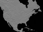
Free Picture: Anaglyph, North America
|
Description
This anaglyph (stereoscopic view) of North America was generated with data from the Shuttle Radar Topography Mission (SRTM). It is best viewed at or near full resolution with anaglyph glasses. For this broad view the resolution of the data was first reduced to 30 arcseconds (about 928 meters north-south and 736 meters east-west in central North America), matching the best previously existing global digital topographic data set called GTOPO30. The data were then resampled to a Mercator projection with approximately square pixels (about one kilometer, or 0.6 miles, on each side). Even at this decreased resolution the variety of landforms comprising the North American continent is readily apparent. Active tectonics (structural deformation of the Earth's crust) along and near the Pacific North American plate boundary creates the great topographic relief seen along the Pacific coast. Earth's crustal plates converge in southern Mexico and in the northwest United States, melting the crust and producing volcanic cones. Along the California coast, the plates are sliding laterally past each other, producing a pattern of slices within the San Andreas fault system. And, where the plates are diverging, the crust appears torn apart as one huge tear along the Gulf of California (northwest Mexico), and as the several fractures comprising the Basin and Range province (in and around Nevada). Across the Great Plains, erosional patterns dominate, with stream channels surrounding and penetrating the remnants of older smooth slopes east of the Rocky Mountains. This same erosion process is exposing the bedrock structural patterns of the Black Hills in South Dakota and the Ozark Mountains in Arkansas. Lateral erosion and sediment deposition by the Mississippi River has produced the flatlands of the lower Mississippi Valley and the Mississippi Delta. To the north, evidence of the glaciers of the last ice age is widely found, particularly east of the Canadian Rocky Mountains and around the G
Keywords
3d, active tectonics, anaglyph, appalachian mountains, black hills, canadian rocky mountains, clearwater lakes, earth science, geography, great lakes, great plains, gulf of california, jpl, lateral erosion, mississippi delta, mississippi valley, nasa, north american continent, ozark mountains, pacific north american plate, rocky mountains, san andreas fault, tectonics, the great lakes, north america, free photography, free photo, free photos, free picture, free pictures, free image, free images
|
Similar Free geography Pictures
|
|
|
|


