|
TERMS OF USE:
This free image can only be used for non-commercial, personal
website use only. THIS IMAGE CANNOT BE
used in galleries, downloaded to your computer, posted on sites for
others to use, manipulated, downsized, or upsized. If you are confused about the
terms of use or have any questions then contact us before using the image.
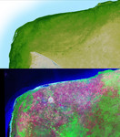
Free Picture: Yucatan Peninsula, Mexico
|
Description
The top picture is a shaded relief image of the northwest corner of Mexico's Yucatan Peninsula generated from Shuttle Radar Topography Mission (SRTM) data, and shows a subtle, but unmistakable, indication of the Chicxulub impact crater. Most scientists now agree that this impact was the cause of the Cretatious-Tertiary Extinction, the event 65 million years ago that marked the sudden extinction of the dinosaurs as well as the majority of life on Earth. The pattern of the crater's rim is marked by a trough, the darker green semicircular line near the center of the picture. This trough is only about 3 to 5 meters (10 - 15 feet) deep and is about 5 km (3 miles) wide; so subtle that if you walked across it you probably would not notice it. It is the surface expression of the buried crater's outer boundary. Scientists believe the impact, which was centered just off the coast in the Caribbean, altered the subsurface rocks such that the overlying limestone sediments, which formed later and erode very easily, would preferentially erode along the crater rim. This formed the trough as well as numerous sinkholes (called cenotes) which are visible as small circular depressions. The bottom picture is the same area viewed by the Landsat satellite, and was made by displaying the Thematic Mapper's Band 7 (mid-infrared), Band 4 (near-infrared) and Band 2 (green) as red, green and blue. These colors were chosen to maximize the contrast between different vegetation and land cover types, with native vegetation and cultivated land showing as green, yellow and magenta, and urban areas as white. The circular white area near the center of the image is Merida, a city of about 720,000 population. Notice that in the SRTM image, which shows only topography, the city is not visible, while in the Landsat image, which does not show elevations, the trough is not visible. Two visualization methods were combined to produce the SRTM image: shading and color coding of topographic height. The shade ima
Keywords
chicxulub, chicxulub impact crater, crater, craters, earth science, geography, impact crater, jpl, mexico, nasa, peninsula, yucatan, yucatan peninsula, free photography, free photo, free photos, free picture, free pictures, free image, free images
|
Similar Free geography Pictures
|
|
|
|


